Portugal: Global exploration inspired by Prince Henry the Navigator
11/28/15 • Written by Julianne
Portugal--a small country on the edge of the continent--was first in global exploration. Beginning in the early 1400's, explorers in small boats began pushing ever further southwards and further out into the Atlantic. How did they do that? Why then?
It seems to be a story of scientific inquiry, deliberate invention or adaptation of known technology and widely shared knowledge.
Portugal, under the guidance of Prince Henry the Navigator, took giant strides in shipbuilding and navigation. He formed the Sagres School of Navigation in southern Portugal where he was governor. The school attracted sailors, geographers, instrument makers, shipbuilders from all over Europe. It sounds to me like the equivalent of a think-tank of shipping and navigation. The Renaissance approach to learning and knowledge was applied to ships and navigation.
Captains, fishermen, merchants and anyone with knowledge of sailing or shipbuilding were brought together. Henry was particularly interested in exploring southward along the coast of Africa and into the Atlantic. Under his auspices, explorers used new navigation techniques to sail out of sight of land and make their way to the Horn of Africa. The Portuguese caravel was developed as an ideal ship to sail into the wind. The scientific approach to acquiring and testing information then teaching newly understood techniques seems to have been a new approach. It was wildly successful and ushered in the modern world. Most of the big names in world exploration spent time at the Sagres School including Magellan and Columbus. Vasco Da Gama, the first European to reach India by sea is another Sangres alum.
As I have gotten older and become more aware of all the ways things can go wrong, I am more in awe of the brave people who got in small boats and explored the world. In recent months, I have been in Iceland looking at the fragile-seeming craft which were the high tech machines of the 900's that allowed the settlement of Iceland, Greenland and Newfoundland. When we were in Holland, we were staying in the area where the whalers returned with their oil in the 1100's from far north expeditions. In both cases, they had navigational knowledge and technical advances that allowed them to go farther.
In earlier travels, I have been intrigued by Portuguese remains, all from the early 1500's. In Malacca, Malaysia and Mombasa, Kenya I visited the remains of fortifications. Far inland in Ethiopia, west of Addis, a stone bridge which is still used was built by the Portuguese. (It is a good perch to see Lammergeyers and other birds of prey from above.) Thus, I am pleased with the chance to learn more about the early Portuguese exploration. The Museum is housed in part of the Jerenoimos Monastery built tin 1502 to celebrate the "Heroic Discoverers." It is a specifically Portuguese building style and quite grand. It is in Belem, the port from which many of the journeys set sail.
Lisbon was thoroughly destroyed in an earthquake in 1755 but it seems that the monastery survived. The earthquake and associated tsunami and fires destroyed much of the city, including many of the records of the early voyages and the plans and drawings of the early ships. Vasco da Gama's reports of his journey to India, for example, were completely destroyed. However, the Museum and University have reconstructed the ships from written accounts, paintings, drawings which survived either here or elsewhere.
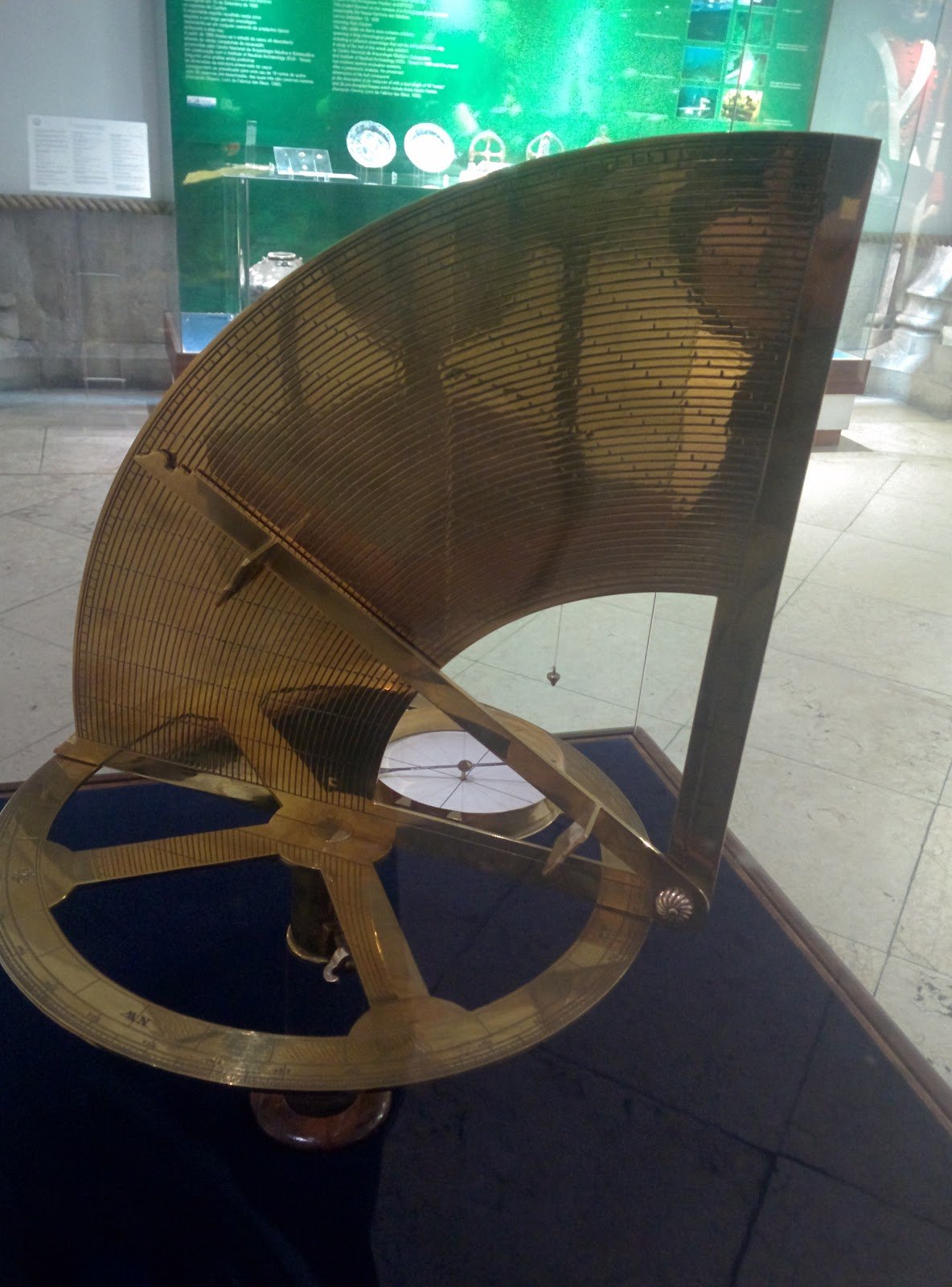
Instruments
Prince Henry's School developed the use of the astrolabe and quadrant (which had been known in the middle ages) for navigating away from land. By using the instrument, a captain could know his latitude. The astrolabe allowed the navigator to create a chart of the sky where they were located, the quadrant allowed them to sight on Polaris, the sun or some other known body and determine how many degrees north or south the ship was located. (Longitude was not figured out until the 18th C.)
For example, Polaris, the North Star, was known as a fixed point in the northern sky. The edge of the quadrant was lined up with Polaris and the pendulum would swing X degrees of the circle. (The 360 degree circle had been defined before this time.) Based on where the pendulum swung to, the ship was X degrees north. As explorers dipped south Polaris was no longer available so the sun and later the southern cross were used.

Maps and charts
Under Prince Henry,knowledge from any captain or sailor who could be induced to tell, was used to create maps and charts for dissemination to those visiting the school. Explorers sent by Henry were specifically required to chart the coasts for future mariners use. Information about recently discovered areas was available beyond merely personal knowledge.


Ships
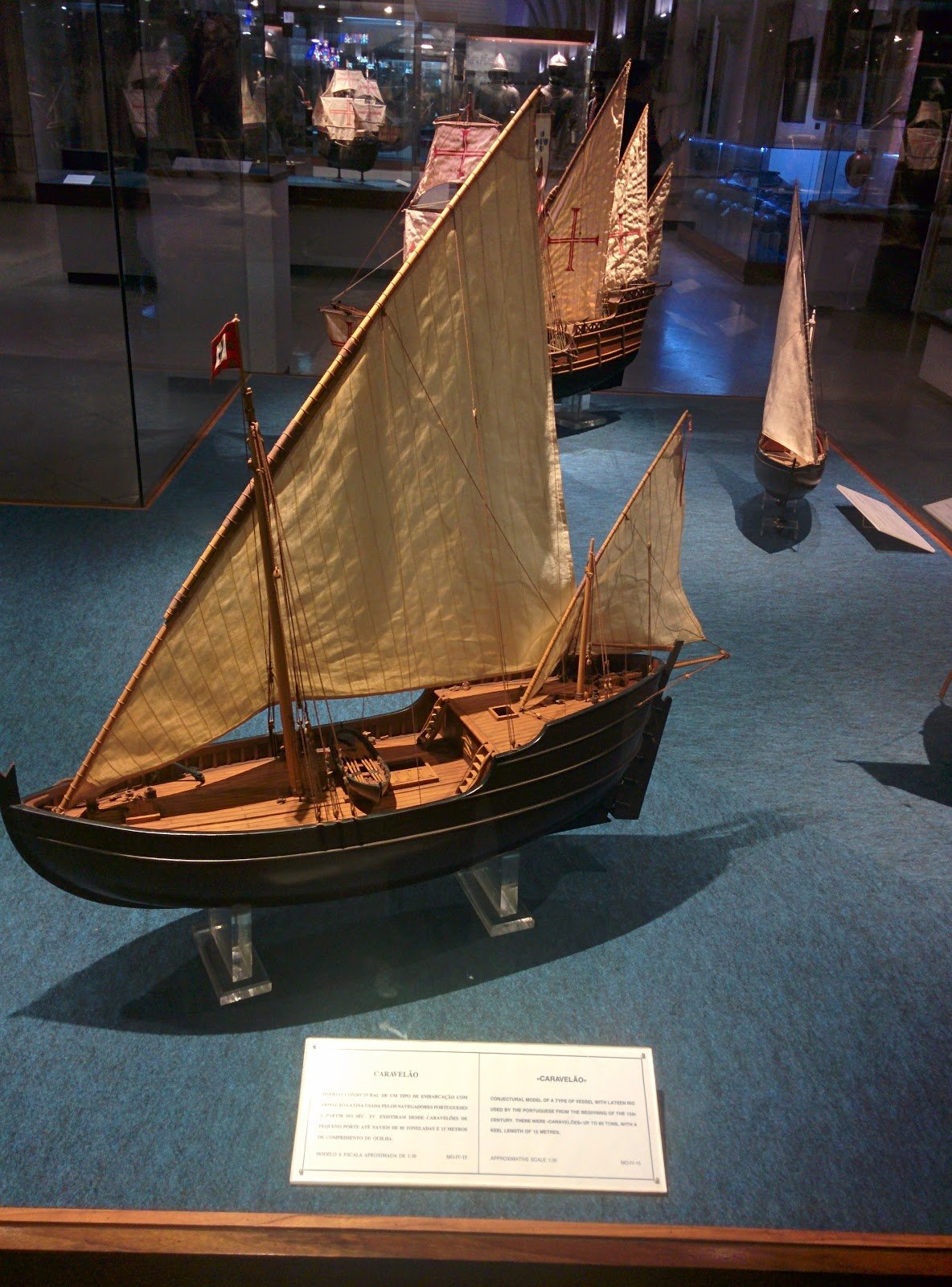
Caravels were adapted from a common ship used in the Mediterranean. Small and flexible, they were adjusted for the rough water of the Atlantic. Their two lanteen sails allowed the sailors to take full advantage of the wind. Later caravels used square sails on the same kind of rigging to take more advantage of the wind. Caravels were about 15 meters long (seems tiny to me). This ship became the workhorse of the explorers and merchants travelling the Africa and later Brazil routes. Columbus's smaller ships were caravels. The small boat below the caravel, a barque, was the support for the caravel and could squeeze in to shore to help develop charts.

Other ships followed--bigger, stronger, more carrying capacity. Here they are in time order but with no particular description of their technology--it is not well explained and beyond my low-tech mind anyway. The center of Portuguese maritime industry had moved to Lisbon after Henry's death in 1460, but the concept of analysis, improvement and shared knowledge continued.
I am not that clear as to how widely knowledge was freely available. The Dutch whalers certainly guarded their routes to their territories in an earlier era. But Magellan studied with Henry and then got the monarchy of Spain to support his voyages. Similarly Columbus, himself a Genoese. So the Portuguese effort was used by their competitors to explore and compete for colonies and natural resources. It seems amazing to me that knowledge was so freely shared.


After the 1775 earthquake, Portugal was overtaken by the Spanish in trade and exploration of the Americas. Portugal was an ally of Britain from early days and seems to have shared technology with them at least sometimes Eventually Britain became the powerhouse of the Indian Ocean and Portugal declined in importance.
Here is a statue of Henry in the museum. I have no idea how accurate his features are--the statue was created in the 1930's. He is always shown with the big hat. Although Italian painters were active in Portugal during his lifetime, most paintings and drawings from his era were destroyed in 1755. But his achievements were immense.
Text and photos by Julianne.


Pretty good grafitti stencils and posters for the International Day of Eliminating Violence Against Women (UN declaration for November 25).